Mapping & Measurement
Land measurement and geospatial data analysis services
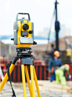
Mapping & measurement are professions closely related to measurement, mapping, and geospatial data analysis. Both play a crucial role in various sectors, such as construction, mining, transportation, and natural resource management. Below is a detailed of the work of surveyors and mapping professionals. Aspect: Measurement, Mapping. Work Focus: Direct measurement of land surfaces and physical elements, Creating and analyzing maps and survey data. End Result: Measurement data in the form of coordinates or dimensions, Maps or geospatial data visualizations. Work Methods: Using measurement tools in the field, Using software and geospatial data. Key Technology: Total Station, Theodolite, GPS Geodetic, Auto Level, ArcGIS, Civil3D, etc. Orientation: Precision in measurement and physical documentation, Data visualization and spatial analysis.